|
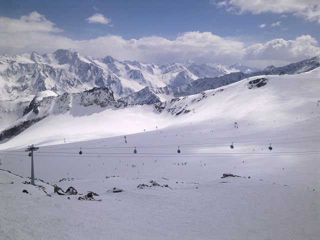
Giggijoch is a prominent mountain and ski area located near the
town of Sölden in the
Ötztal Alps of Tirol,
Austria. It is one of the main access points to the ski resort in the Sölden
region and offers stunning views and a variety of activities year-round.
Key Features of
Giggijoch:
-
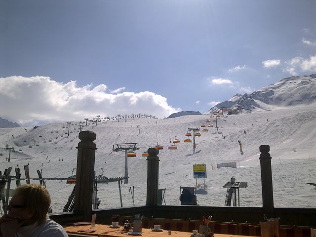
Skiing and Snowboarding:
-
Sölden Ski Resort:
The Giggijoch is
one of the two main ski mountains in Sölden (the other being
Gaislachkogl). It
offers a wide range of slopes for all levels of skiing and
snowboarding, from beginner to advanced. The area is part of the
Ötztal Glacier ski
region and provides access to over 145 kilometers of slopes.
-
Snowboarding and Freestyle:
The Giggijoch area also features terrain parks for freestyle skiing
and snowboarding. It is a popular spot for freestylers looking to
hit the jumps and obstacles in the area.
-
Accessibility:
-
Giggijochbahn: The
Giggijochbahn is a
modern gondola lift that connects the valley station in Sölden to
the top of Giggijoch. The lift offers comfortable access to the
slopes and is a central part of the ski infrastructure in the area.
-
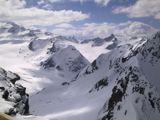
Panoramic Views:
Giggijoch offers incredible views of the surrounding mountains,
including the Ötztal Alps
and glaciers. It’s a popular spot for taking in the scenery, especially
for those looking to enjoy the majestic alpine environment.
-
Summer Activities:
-
Hiking: In the
summer months, Giggijoch is a starting point for various hiking
trails in the area. These trails range from easier, family-friendly
walks to more challenging mountain hikes. Hikers can explore the
beautiful alpine meadows and experience the stunning natural beauty
of the region.
-
Mountain Biking:
The area is also popular for mountain biking, with several trails
suitable for different skill levels. The
Ötztal Bike Trail
connects several villages, including Sölden, making it a great way
to explore the Ötztal Valley by bike.
-
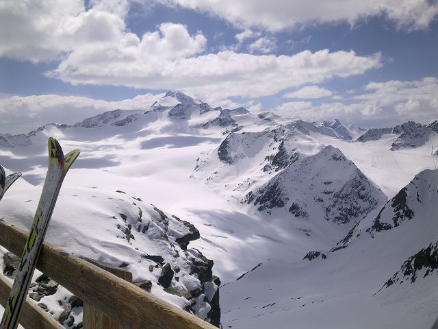
Giggijoch Summit: The
summit of Giggijoch offers one of the best panoramic viewpoints in the
region. It’s a popular spot to stop and take in the spectacular views of
the surrounding peaks, glaciers, and valleys. In winter, it's a great
place for a scenic break while skiing, and in summer, it's perfect for
enjoying a relaxing day in the mountains.
-
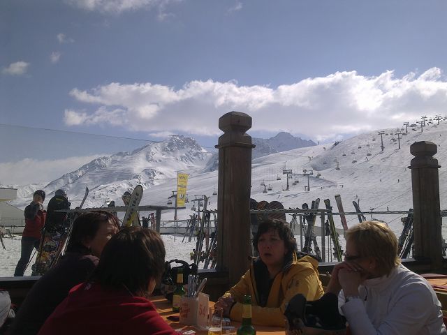
Après-Ski: Like the
rest of Sölden, Giggijoch has its share of après-ski options, where
visitors can relax and unwind after a day of skiing or hiking. There are
cozy mountain huts and bars where you can enjoy traditional Tyrolean
food and drinks, including warming mulled wine or schnapps.
Best Time to Visit:
-
Winter: For skiing,
snowboarding, and other winter sports, the best time to visit is from
December to April when the snow conditions are ideal.
-
Summer: For hiking,
mountain biking, and enjoying the alpine scenery, late spring through
early autumn (May to September) is the best time to visit.
Giggijoch is a central hub for outdoor
activities in Sölden and a must-visit for anyone spending time in the
region. Whether you're there for the ski season or exploring the summer
trails, it offers an incredible experience in the heart of the Alps.
|
ennerhorn is a mountain peak located in the
Ötztal Alps in Tirol,
Austria. It is situated near the town of
Sölden and is part of the
stunning alpine scenery that defines the region. While the Gennerhorn is not
as widely known or popular as some of the other major peaks in the Ötztal
Alps, it offers a great spot for hiking and mountaineering, providing
beautiful views and a more tranquil experience compared to the more crowded
ski areas like Giggijoch or Gaislachkogl.
Key Features of
Gennerhorn:
-
Mountain Hiking and Summit:
- The Gennerhorn is accessible via
hiking trails, making it a great destination for those who enjoy
mountaineering. The peak stands at around
3,155 meters
(10,350 feet), offering stunning panoramic views of the surrounding
mountains, including the
Ötztal Valley and nearby glaciers.
- It is a more remote peak, and
getting to the summit requires solid hiking or mountaineering
skills. The trail is typically more challenging and less crowded,
making it ideal for experienced hikers or those seeking more
solitude in nature.
-
Scenic Views: The
summit of Gennerhorn
offers spectacular vistas over the
Ötztal Alps,
Tiefenbach Glacier,
and surrounding peaks. On clear days, the view from the summit stretches
for miles, offering incredible photo opportunities and an impressive
view of the glacier-covered mountains.
-
Nearby Attractions:
-
Tiefenbach Glacier:
While hiking or climbing in the area, the
Tiefenbach Glacier
is a notable nearby attraction. It is one of the glaciers in the
region and is accessible to skiers in winter. The glacier also
offers a fantastic view of the high mountains surrounding Sölden.
-
Sölden: The
nearby town of Sölden
offers access to the major ski resorts, restaurants, and
accommodations, providing a good base for hikers exploring the
region.
-
Summer and Winter Activities:
-
Summer: In
summer, Gennerhorn and the surrounding region are great for hiking,
mountaineering, and alpine exploration. The Ötztal Alps are known
for their stunning landscapes, and hiking trails provide access to
some of the best views in the area.
-
Winter: Although
the focus of Sölden is on skiing, the area surrounding Gennerhorn
can also provide opportunities for
ski touring or
backcountry skiing
for more experienced skiers and mountaineers looking for an
adventure beyond the groomed slopes.
-
Wildlife and Flora:
As with much of the Ötztal Alps, the Gennerhorn region is home to
diverse wildlife, including marmots, ibex, and alpine birds. The flora
includes alpine flowers and hardy vegetation that thrive in the
high-altitude conditions.
Best Time to Visit:
-
Summer (June to September):
This is the best time for hiking and mountaineering. The trails are
clear, and the weather is generally mild, making it ideal for exploring
the alpine terrain.
-
Winter (December to April):
For those interested in ski touring or winter mountaineering, the colder
months provide opportunities to explore the snow-covered region.
However, this requires expertise in alpine conditions.
Access and Logistics:
-
Sölden: The closest
town to Gennerhorn is
Sölden, which is easily accessible by car from Innsbruck or other parts
of Tirol. From there, hikers and climbers can access the trailheads that
lead to the mountain.
-
Guides: Given the
challenging terrain, it might be a good idea to hire a guide if you’re
unfamiliar with the area or the technical aspects of alpine hiking or
mountaineering.
|
Das abwechslungsreiche Angebot umfaßt:
- 68 km blaue Pisten
- 50 km rote Pisten
- 28 km schwarze Pisten
- 2 km Skiroute
vom einfachen Gelände für Anfänger/Leicht-Fortgeschrittene am Giggijoch
zu einer Vielzahl anspruchsvoller Pisten am Skiberg Gaislachkogl. Der
Gaislachkogl (3.058m) ist außerdem sehr beliebt bei all jenen, die abseits
des gesicherten Skiraums ihre Spuren in den Schnee ziehen möchten.Sölden ist
für seine breiten und perfekt präparierten Pisten bekannt, die täglich zur
Gänze mit den 26 Pistengeräten präpariert werden.
|
- Gaislachkogl (3.058 m)
- Tiefenbachkogl (3.250 m)
- Schwarze Schneide (3.340 m)
ABSOLUTE SCHNEEGewaehr
von Oktober bis Mai durch
- die Höhenlage des Skigebiets (1.350 - 3.340m)
- 2 Gletscherskigebiete am Rettenbach- &
Tiefenbachgletscher
- maschinelle Beschneiung von 90,2 km (rund 60%) der Pisten
|
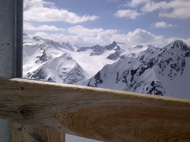
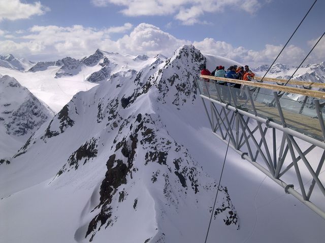
Aussichtspunkte:
- BIG3 Schwarze Schneide (3.340 m):
von der Bergstation der 8EUB Schwarze Schneide 15 min. (90 Höhenmeter) zu
Fuß zur Naturplattform aufsteigen. Blick bis in über 100 km Entfernung
(Dolomiten, Marmolada, Ortler, Zugspitze)
- BIG3 Tiefenbachkogl (3.250 m):
direkt an der Bergstation der 8EUB Tiefenbach befindet sich der
freitragende Panoramasteg, der 20 m hinausragt, die Wildspitze (3.776 m) -
höchster Berg Tirols ist zumk Greifen nahe
- BIG3 Gaislachkogl (3.058 m):
direkt an der Bergstation der Gaislachkoglebahn befidnet sich die
ellypsenförmige Aussichtsplattform, auch für Fußgänger erreichbar.
- Rotkogelhütte (2.660 m):
an der Drehscheibe des Skigebiets zwischen Giggijoch und der
Gletscherverbindung erwartet Sie ein herrlicher Ausblick auf den
Retenbachgletscher und die Nordseite des Gaislachkogls mit seinen
unzähligen Rinnen.
|
Die längsten Abfahrten:
- Abfahrt von der BIG3 Plattform der Schwarze Schneide (3.340 m) zur
Talstation der Gaislachkoglbahn (1.370 m):
Höhenunterschied: 1.970 m
Länge: ca. 15 km
- Abfahrt von der BIG3 Plattform Gaislachkogl (3.058 m) zur Talstation
der Gaislachkoglbahn (1.370 m):
Höhenunterschied: 1.688 m
Länge: ca. 10 km
- Abfahrt von der Bergstation 4SK Rosskirpl (2.744 m) zur Talstation der
Giggijochbahn (1.353 m)
Höhenunterschied: 1.391 m
Länge: ca. 9 km
- Abfahrt von der Rotkoglhütte (2.660 m) zur Talstation der
Gaislachkoglbahn (1.370 m)
Höhenunterschied: 1.290 m
Länge: ca. 8 km
|
 Safaris
Bergsteigen
Wandern
Inselwandern Weltweit
Safaris
Bergsteigen
Wandern
Inselwandern Weltweit
 Chronologie
Inselwandern
Chronologie
Inselwandern Europa
Inselwandern
Europa
Inselwandern
 Städtewandern
 Paintings
 Dirk Rauschenbach